


javols

FLORENSAC
User
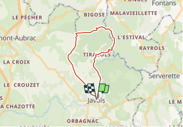

Length
11.6 km

Max alt
1064 m

Uphill gradient
292 m
Km-Effort
15.5 km

Min alt
937 m

Downhill gradient
292 m
Boucle
Yes
Creation date :
2025-04-13 19:41:40.729
Updated on :
2025-04-13 19:41:43.826
3h31
Difficulty : Difficult

FREE GPS app for hiking
 SityTrail
IGN / Geographical institutes
SityTrail Plus
The world is yours!
About
Trail Walking of 11.6 km to be discovered at Occitania, Lozère, Peyre en Aubrac. This trail is proposed by FLORENSAC.
Description
une boucle en passant par le baou de l estival en longeant la truyere
un morceau du chemin de Saint jacques
retour vers Javols en traversant le cheylaret (four a pain)
Positioning
Country:
France
Region :
Occitania
Department/Province :
Lozère
Municipality :
Peyre en Aubrac
Location:
Unknown
Start:(Dec)
Start:(UTM)
527072 ; 4948865 (31T) N.
Comments